All our services are fee-based, and we do not offer free proposals. A token amount is required to initiate. We are open to discussing our rates and availability to find the best solution.
Get your design ready in 24 hours.
Our prices starts from 3999/.
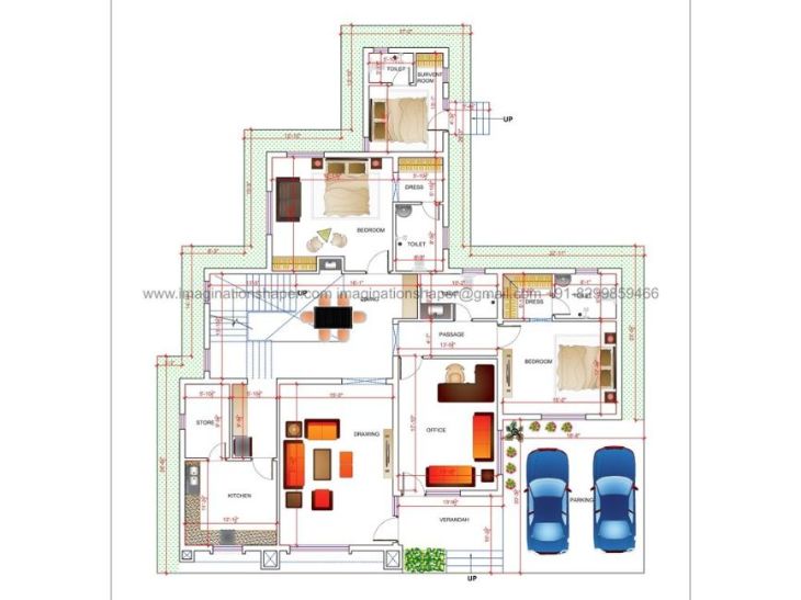

Get best customized house plan designed by experienced architects and designers.


Are looking for the elevation design services, Imagination would be the perfect option.


Home interior design to enhance the interior of the project services at an affordable price.


Design your health care project as per guidelines, the user and patient-centric also.


We incorporate sustainability strategies, creative space planning and best technology.

We are focused on combining function with style to meet the need of businesses.
A Comprehensive Guide for Total surveyor station in Lucknow.
Introduction:
Total stations are the necessary tools for modern surveying system, which combines the electronic distance measures with angular measures. Lucknow city is well known for its culture and history the city includes the rapid urban development, and the use of total stations in Lucknow has become growingly essential for correct land surveying, construction, as well as infrastructure projects. This guide will cover explore the total stations in Lucknow, applications, as well as specific considerations of usage in Lucknow.
Imagination Shaper in Lucknow offers the total survey services at the best in the city including all the basic needs to specific construction needs. So let’s dive in it.
A total station is a surveying system which is combines the electronic theodolite and electronic distance meter to provide the perfect measurements of horizontal as well as vertical angles and distances. It generally uses in the construction, and land surveying projects as well to collect the information to create detailed maps, plans, as well as 3D models.
How total survey station works?
A Total Station has a telescope, computer, as well as reflector. The telescope is used to point at target location, EDM measures the distance to targeted location through sending a laser beam and measure the time it takes for a beam to reflected back. And this time is used to measure a distance to targeted location.
The telescope has a built-in electronic transit which is use to measures horizontal and vertical angles of the targeted location. Total station’s computer receives this data from EDM as well as from the theodolite and the computer processes this data to give it to the user according to users need.
The total station is also capable to store data on instrument, and allows for easy transfer to computer and other devices for further processing. Some total stations are controlled remotely, and allows user to take measurements from the safe distance.
Some total stations are capable to connect with external devices like GPS receivers, which allows to integrate total station data with GPS data, offering a more perfect and detailed survey. This feature is useful when large-scale projects required where high level of accuracy is needed.
There are various types of total stations, and they all have different features like robotic total stations which is able to move telescope as well as rotate instrument to a new point with just pressing one button.
It also includes the robotic controller, which allows it to get controlled by remote from a data collectors point. It is useful for larger projects where multiple measurements required to be taken from various positions.
Stations are available in various types based on the technology used in their construction. The technology used in it determines the accuracy, range, as well as applications:
Electronic stations are most common type of total stations used in surveying and construction as well. They use electronic distance measurement methods to measure the distances and angles. Electronic stations can accurately measure distances up to several kilometres.
GPS stations uses the satellite technology to measure distances and angles as well. They are best option for large-scale surveying projects where accuracy as well as speed are important. GPS stations are accurate and best option to measure distances up to several kilometres.
Application and uses of then total surveyor station:
High precision:
Total station surveying is known for its high precision, making it ideal for projects that require very accurate measurements.
The ability to measure both angles and distances:
Total station surveying can measure both angles and distances, allowing for the calculation of coordinates for any point.
Can be used in difficult-to-access areas:
Total station surveying can be done in difficult-to-access areas, such as on steep slopes or in dense forests, as long as the surveyor can see the target.
Versatility:
Total stations can be used for a variety of surveying tasks, including topographic surveys, construction layout, and as-built surveys.
Conclusion:
The total station survey serves offers an extensive guide for professionals in the field of surveying, providing detailed insights of operation, application, as well as benefits of using total stations. This guide have discusses the types of total stations in surveying, application and uses of total survey station and its advantages available to use for different project needs.
Knowing how to use total station in surveying is essential for accurate data collection and analysis, and to provide step-by-step instructions, making sure about the users can improve the efficiency and precision in their surveys. Contact us today at Imagination Shaper in Lucknow for your total survey.
Houses and plan
Design a home plan
House exterior design
Duplex house blueprint
Structural engineer consultant
Architectural home design
Home design blueprint